Memoirs and Memories—Remembering the Rituals and Curative Qualities of our Holy Wells
Memoirs and Memories—Remembering the Rituals and Curative Qualities of our Holy Wells
Keith D. Lilley
Maps have gaps.
One of our motivations for focusing on holy wells in Northern Ireland as part of the 2020 CBA ‘Festival of Archaeology’ is to raise greater awareness and appreciation of their ‘hidden heritage’. Looking at the map of holy wells for Ireland that Dr Ray’s Holy Wells County-by-County Project has created, this ‘hiddenness’ of the holy well is especially apparent for the north-east of Ireland, for compared to other parts of the island of Ireland there is a sparsity in the north. Why is this?
A reason why perhaps the holy wells of Ireland are less visible in the north than in other parts of the island may in part be due to differences in their recording and visibility in the local landscape. This leads us to contemplate how it is that some historic holy wells continue to have a presence while others have been forgotten or neglected. The continued veneration of wells locally is in part perhaps a major factor in this, but so too is an issue raised by Dr Ray in her opening guest blog. She points out how,
In Northern Ireland, the survey of ancient monuments was selective and in the 1940s holy wells were ruled out for inclusion: “The principle of selection” was “to omit raths, standing stones, holy wells, ruins without architectural features, unless they are remarkable either for their historical associations or for their appearances.”
quoting here from Oliver Davies’ ‘A Preliminary Survey of the Ancient Monuments of Northern Ireland, conducted by the Ancient Monuments Advisory Council for Northern Ireland’, of 1941.
This ‘official’ silencing of holy wells from archaeological enquiry has deeper roots, and begins to explain gaps on maps, and this I contend has much to do with the folkloric associations of holy wells perpetuated through their ritual and medicinal uses by local people.
The Ordnance Survey (OS) maps of Ireland still record holy wells, as ‘named antiquities’, and so it is that on some modern sheets of the 1:50,000 scale Discovery Series (for Ordnance Survey Ireland) and Discoverer Series (for Ordnance Survey Northern Ireland) are peppered with dots and accompanied by the words ‘Holy Well’. Great for the holy well researcher and field-worker to locate the sites of holy wells, but at the same time disconcerting where large expanses of map sheets are devoid of any mention of a holy well, and here we need to look a bit more closely at the map and who made it and why.
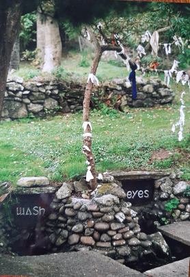
On the historic 6-inch to one mile First Edition Ordnance Survey map for the southern tip of the Ards peninsular in County Down, there is a curious absence. St Cooey’s Wells today have been restored by local people, and from the Northern Ireland official tourism web-site, the modern visitor to the area is informed how,
Pilgrimage to the site takes place annually on the Sunday nearest to the feast of Saints Peter and Paul. The Washing, Eye and Drinking wells situated in this peaceful, wooded dell are reputed to have healing powers. Certainly, the number of “rags” attached to nearby thorn trees attests to the well’s reputation for healing. A path from the wells leads through a reedbed to the shore where hollows in a slab of rock are said to mark where St Cooey knelt to pray.
There seems to be no doubt about the wells’ importance locally and their respected curative and medicinal potency. Search the First Edition OS map for the area however, surveyed in the 1830s, and there is no mention of the site of St Cooey’s Wells...

The site of St Cooey’s Wells and the 6” First Edition Ordnance Survey map
(County Down Sheet number 32, surveyed 1834)
Thanks to the Public Record Office of Northern Ireland’s (PRONI) ‘historical map viewer’, the OS 6” map-sheets are easily accessible and examined. These maps are such a fascinating insight into how the landscape looked in the past, but there are gaps on the maps as far as holy wells are concerned, as St Cooey’s Wells illustrates. The locality, however, and the associations of the wells’ curative and medicinal value, lives on locally in the memories of those who frequent the wells and keep them in living memory.
The OS surveyors in the 1830s did not record the wells of St Cooey, and neither did Lieutenant Henry Tucker in his ‘Memoirs’ of the Ards parish of Ballyphilip, gathered as part of the Ordnance Survey’s work on the island of Ireland, which were designed to accompany the 6” maps. The modern edition of the OS Memoirs for the Ards area, by Angélique Day and Patrick McWilliams, notes how here ‘The Memoir writers were fairly concise in their description of parishes, possibly due to lack of time…’ (Ordnance Survey Memoirs of Ireland, Parishes of County Down II, 1832-4, 1837, North Down and Ards). In some cases, holy wells do appear in the OS Memoirs, featuring often as an entry placed under sections on ‘Ancient Topography and Antiquities’, as for Streull Wells, near Downpatrick, where a detailed account of their medicinal uses and associated rituals is recorded by M M Kertland in the OS Memoirs of 1837 for the area; and nearby at Killough, the OS Memoirs record ‘the ruins on the roadside’ of St John’s Well, and ‘another saint’s well a little to the south of Killough’, called ‘St Scordin’s Well’ (Ordnance Survey Memoirs of Ireland, Parishes of County Down IV, 1833-7, East Down and Lecale). None of these wells, however, currently appear on the digital map featured in the Holy Wells County-by-County Project, an easy gap for us to fill.
The enduring impacts and legacies of the Ordnance Survey surveyors, memoir writers and map-makers, of two-hundred years ago, continue to affect how we see holy wells today in the north of Ireland. The predilections and circumstances of those surveying Ireland in the 1830s have to be considered today, ‘it is likely that traditions of saints and holy wells are mentioned because of their proximity to ancient remains or their attachment to names of places and not from any concerted effort to seek them out’, suggests Stiofán Ó Cadhla in the book, Civilizing Ireland. Ordnance Survey 1824-1842, which explores the recording of Ireland’s folklore by the OS. And here, perhaps, the local memories and rituals associated with holy wells played a part on their visibility to those outsiders, the OS surveyors, who encountered them in their traverses across the landscapes of Ireland.
Today, while we have to grapple with these gaps on maps, an opportunity presents itself for those interested in reconnecting the anthropology and archaeology of holy wells in Ireland. Of not seeing the folkloric aspects of holy wells as separate from the material aspects of their remains, but instead as integral, is key to what it is that gives these sites their character and appeal. The curative, health and healing qualities of our holy wells is a defining trait that makes a well special to those who visit it and remember it, indeed it is one of the common and universal characteristics of holy and sacred wells and watering places the world-over, as this is not something that is singularly peculiar to Ireland. Without their stories and associations, wells have no depth. Our task, now, is surely to keep these memories alive, to recover them where they have been lost, and to repopulate our maps with holy wells, filling in those gaps left by others.
Recording the curative and medicinal qualities of particular wells is as important as marking the site with a dot on a map. And here, Dr Ray’s Holy Wells County-by-County Project provides us with a significant opportunity to do this, for future generations, and so redress the ‘hidden heritage’ of holy wells that our maps and memoirs of the north of Ireland have for too long forgotten. Searching out this hidden heritage has itself ‘curative’ and healing benefits, connecting us to our roots, to localities, to memories and communities, for heritage is well-known today for its restorative and beneficial health qualities. As Ireland pulls through a major health crisis with coronavirus in 2020, our reconnection with places and localities of the past has particular resonance, and importance, and holy wells, as part of this ‘heritage landscape’, have a key role to play in this. The waters of holy wells still draw us, they invite us to contemplate, to reflect, on our past, our present and our futures.